Aerial Birds Eye View Services USA

Ever Wonder What it Would Be Like to Look Down on Your Project from the Sky? Aerial photography has transformed the world of business and industry, uncovering views beyond your dreams. From property to building, farming to event management, aerial photography and video provide unmatched insights, marketing opportunities, and surveillance of your project.
At Bottom Line Studio, we provide Aerial Birds Eye View Services USA throughout the USA with high-definition photography, 4K video, and big-picture mapping solutions. Utilizing state-of-the-art drones, helicopters, and satellite imagery, we assist companies with acquiring exquisite overhead imagery for any purpose.
Our services are provided to customers across the nation, offering excellent aerial imaging solutions for real estate marketing, infrastructure development, agriculture mapping, tourist planning, and others. For any high-definition video or live aerial coverage of events, our professional solutions to your requirements are available.
Why Bottom Line Studio for Aerial Birds Eye View Services?
Expertise in Aerial Imaging
Bottom Line Studio is a name to remember for aerial image solutions with top-notch 3D rendering aerial view photography and videography services all across the USA. Our experts have enough experience in the industry and understand the technical as well as the creative elements of aerial imaging. Every project is taken with the utmost care so customers receive premium visuals specifically customized according to their precise specifications. Our services cut across a wide spectrum of industries, such as real estate, construction, agriculture, urban planning, and tourism, with customized solutions optimizing operations and advertisement campaigns.
Sophisticated Gadgets for Unparalleled Quality
Aerial photography quality greatly relies on equipment used by Bottom Line Studio, which utilizes expensive drones, helicopters, and satellite imagery to capture aerial scenes with breathtakingly magnificent beauty. Our high-quality fleet of drones comes equipped with 4K ultra-HD cameras, thermal camera technology, and LiDAR scanning systems to take neat, crisp, and highly clear aerial photos and videos. For wide, bird’s-eye views of large projects, our helicopter and satellite imagery services offer a wider view with greater clarity.
Certified and Professional Drone Pilots
Safety and regulatory compliance are given top priority in 3D aerial view renderings, photography, and videography. All our pilots at Bottom Line Studio are FAA-certified, and as a result, all of our flights strictly comply with regulatory and safety protocols. They also possess extensive experience flying over numerous types of landscapes and environments and are qualified to carry out aerial imaging tasks over urban and rural landscapes. From our aerial photos of Florida beachland property, Arizona desert landscapes and terrain, and New York skyscrapers, our firm takes the extra step to make it an easy, professional experience.
Custom Aerial Imaging Solutions
Each job is unique, and we know businesses and industries have particular aerial imaging needs. Bottom Line Studio, an architectural 3D aerial view rendering company, offers fully customized solutions, tailoring our services to the very individual needs of companies, professionals, and individuals. To our residential customers, we provide breathtaking aerial flights over residences, focusing on surroundings and amenities. Our 3D mapping and building progress tracking are useful to construction firms, while agricultural firms utilize our precision agriculture aerial photography to boost crops and track irrigation system efficiency.
Nationwide Coverage for Extensive Services
Bottom Line Studio provides 3D Architectural Aerial Renderings services throughout all 50 states with quality aerial imaging for United States organizations. With Chicago, Illinois, urban aerial mapping, California coastline monitoring, and Texas coastline industrial inspections, we have the know-how and capability to provide excellent results. We are familiar with regional airspace rules and will conduct all aerial work within compliance and efficiency.
Quick Turnaround Time for Quality Results
Access to aerial images and video is instantaneous, particularly for commercial markets needing up-to-date information and monitoring of projects. Bottom Line Studio espouses quick turnaround, and the fully post-produced and edited aerial video is ready between 24 and 48 hours. Our upscale post-production enhances images and video to be more qualitative and sees to it that professionally edited video is ready at any time for marketing, reporting, or decision-making purposes.
Industries That Stand to Gain from Aerial Birds Eye View Services
Real Estate & Property Marketing
Aerial photography has transformed the real estate sector. High-definition aerial photos assist realtors, property developers, and investors in marketing properties differently. Prospective clients can see properties as a complete entity, along with the neighborhood, amenities, and surrounding landscape.
Our Aerial Birds Eye View Services USA for real estate are:
- Aerial photos and videos for property listings.
- Cinematic drone video virtual property tours.
- Mapping of land and site for business development.
Monitoring of Construction & Infrastructure
Construction is an integral part of aerial photography. Aerial photography facilitates monitoring of the development by the project manager, engineer, and architect, to remain within guidelines of safety while recording proof of development over the passage of time.
Our construction aerial services encompass:
- Progress monitoring of a site through aerial time-lapse photography.
- Drone inspections for performing safety checks and ensuring the structural integrity of the building.
- Topography mapping and 3D modeling to facilitate efficient development and planning.
Agriculture & Land Management
Farms and agri-business enterprises are dependent upon aerial photography to execute precision farming, crop disease and health analysis, and land surveys. UAVs allow crops, irrigation systems, and pest management to be viewed in real time.
Our agricultural aerial solutions include:
- Monitoring crop health using thermal imaging and multispectral technology.
- Optimal distribution of water through evaluation of the irrigation system.
- Livestock tracking and farm mapping for improved farm management.
Urban Planning & Land Survey
Urban planners and the government use aerial surveys to attain zoning analyses, city planning, and infrastructure work. Experts have aerial images provide visualized presentations of potential future development, environmental impact, as well as land use.
Our urban planning aerial services consist of:
- Infrastructure appraisal for building as well as transportation projects.
- High-resolution images for land use maps and analysis.
- Environmental studies and disaster relief aerial data acquisition.
Events, Tourism & Hospitality
Aerial photography and aerial video capture are now essential for event coverage, tourism marketing, and hospitality advertising. Tourism boards employ stunning aerial photography to promote their destination and welcome visitors.
Our aerial video offerings for events and tourism are:
- Live aerial coverage of concerts, sporting events
- Weddings.
- Hotel and resort promotions aerial videos shot in landscape scenes.
- Aerial adventure travel video shot in landscape scenes and outdoor activities.
Industrial & Energy Sector
Industrial processes such as oil rigs, windmills, and solar farms involve aerial surveying for inspection, asset management, and maintenance. Aerial photography makes it easier to detect inefficiencies, measure damage, and improve operation safety.
Our aerial industrial services include:
- Damage detection inspection of power lines and pipelines.
- Remote monitoring of wind and solar farms for energy efficiency.
- Mass operations asset management and inventory tracking.
Our Aerial Services & Technology
We use cutting-edge technology to create accurate, high-definition aerial images. Our professional 3D Aerial View Rendering Services provide quality photos and accurate data collection for various markets. Our application of advanced drone technology, birds eye satellite views, and machine learning analysis allows us to offer an unparalleled level of clarity and insightful aerial observations to customers. We take care in carrying out every project so that resulting products are flawless and yield useful, actionable outcomes.
High-Resolution Aerial Photographs
Taking great, high-definition photos from the air enables companies to represent buildings, landscapes, and construction sites. Aerial photography is used extensively in real estate promotion, site plans, and travel advertisements. Our high-definition aerial photos assist in making advertising materials more compelling, making property presentations more detailed, and giving an overall feeling of huge developments. With greater clarity and definition, our aerial photos emphasize the best of any area, making them very useful to companies and professionals.
4K Ultra HD Aerial Footage
Aerial video adds a movie-level quality to business advertising campaigns, property marketing packages, and promotional videos. Top-of-the-line drone video is ideal for creating captivating videos that hold the interest of the audience. With stabilized movement and a smooth flight, coupled with hair-raising aerial shots, our videography services come to life with landscapes, properties, and events. For business commercials, tourist promotions, or movie narratives, our aerial videos create stunning imagery that leaves lasting impressions.
3D Mapping & LiDAR Scanning
Urban planning, construction, and environmental studies require aerial mapping. Our drones employ 3D mapping and LiDAR scanning technology to create high-fidelity digital models of topography and structures. These innovative mapping solutions offer accurate terrain modeling, volumetric analysis, and enhanced project planning. High-accuracy 3D Aerial View Visualizations with governments and companies assist them in maximizing land use, enhancing decision-making, and facilitating infrastructure planning.
Thermal Scanning & Infrared Imaging
Thermal UAVs assist in the detection of heat loss, electrical malfunction, and wastage of energy in industrial facilities. Infrared scanning is also utilized in pipeline inspection and wildlife monitoring. These technologies make maintenance proactive, provide early detection of faults in a system, and increase energy efficiency. Our thermal scanning products are used in the oil and gas, manufacturing, and environmental research markets to ensure safety, efficiency, and economy of operation in their operations.
GIS Mapping & Data Analysis
We combine aerial imagery with Geographic Information Systems (GIS) to deliver precise data for land surveying, city planning, and environmental research. GIS mapping is applied extensively in government planning, agriculture, and infrastructure planning. Through the combination of aerial data and geospatial analysis, we enable organizations to optimize land use, monitor environmental change, and improve resource management. Our GIS solutions offer an in-depth understanding of landscapes to enable smarter and sustainable development.
How Our Aerial Services Work
Consultation & Project Planning
We discuss your personal requirements and develop a personalized aerial image plan according to location, company, and project objectives. We comprehend the objective of the project in a way that we are able to assess the most appropriate aerial imagery methods to ensure that your particular requirements are met. Our professionals consider aspects such as weather, flight clearances, and project timelines in a manner that allows them to provide you with seamless and efficient solutions.
Flight Scheduling & Preparation
Our FAA-certified pilots and drone operators conduct pre-flight checks to enable secure and legal operation across the regions. We check airspace prohibitions prior to each flight, acquire required clearances, and perform safety tests to avoid any interference in any operation. We also employ sophisticated flight planning tools to design the most optimal flight paths and ensure full coverage of the area allocated.
Aerial Data Capture
We use state-of-the-art drones, helicopters, and imaging technology to take high-definition images and footage with accuracy and acuteness. Our personnel utilizes varied aerial methods, such as panoramic photography, low-flight fly-over, and 360-degree video shoots, to provide the optimum output. All the flights are carried out using stabilization equipment and AI-based automation, providing crystal-clear, distortion-free shots.
Post-Processing & Editing
Our team professionally edits the pictures and videos taken with professional image and video editing software, sharpening clarity, contrast, and sharpness to provide maximum visuals. This includes color correction, noise removal, and resolution to provide breathtaking visuals. Apart from that, to produce maps and perform survey work, we utilize GIS software and 3D modeling software to provide highly accurate reports and analytic data.
Delivery & Client Review
We ensure quick turnaround with the delivery of aerial photos and videos within 24 to 48 hours so that you receive quality content within your deadlines. Files are given in various formats appropriate for display on the web, print, and digital media, hence convenient to be incorporated in campaigns and reports. Revisions and further refinements may also be undertaken if required to make the end product even more superior than expected.
Contact Bottom Line Studio for Commercial Aerial Bird's Eye View
For professional commercial aerial birds Eye View Services USA, contact Bottom Line Studio. We have high-tech machinery, seasoned pilots, and custom-tailored services to ensure you get aerial images and aerial footages tailored for your purposes.
Contact us now to learn about your project and bring your dream to a different level using professional aerial imaging.
Call us to schedule an appointment for a complimentary consultation, and let us capture the best aerial photos for you!
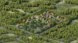
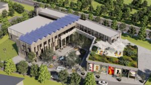
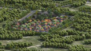
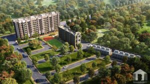
Here are some Aerial Bird's Eye view projects


FAQs
What’s the process to begin?
Contact BottomLine to discuss your requirements, the total count of images or the length of the videos you require, great but not mandatory to fill in a brief form at:
- Animation Brief
- Rendering Brief
- Virtual Reality Brief
And then our expert professionals will guide and advise you in a proficient, and quick manner to evaluate and resolve all the issues that may occur, and develop a budget in a shorter time-span. If you find our proposal interesting then we will be ready to begin.. In order to contact us you can call us @ +91 9873063474 or can send us an email at info@bottomlinestudio.com
How can I assure my private data security?
We at BottomLine Studio strictly follow non-disclosure norms and where necessary we are also ready to sign an agreement of nondisclosure. We take the utmost precautions to guarantee the security of the information or security of the data, or security of the information shared by you.
What information do you need to get started with our project?
You can discuss any information and any imagination you have in your mind. It would be great if you have lighting or landscape plans, 3D files & finishes. Even if you have a hand-drawn rough sketch or hand-drawn floor plans that are also good. We are comfortable with everything and have the capability to go beyond the expectations. But the more information we will get by your side the better we will be able to understand.
Trust & Copyright
Do you have a branch located in our city? Can you send any dedicated people to our office for initial discussion about the project?
We mainly work with the virtual modules and all communication related to the specific project takes place online including file exchange, briefing, project management, previews & delivery. All these operations can be easily carried out virtually irrespective of the location.
We ensure to establish the best communication channel with you online. So without any further second thought you can contact us now!
Here are some Aerial Bird's Eye view projects
FAQs
What’s the process to begin?
Contact BottomLine to discuss your requirements, the total count of images or the length of the videos you require, great but not mandatory to fill in a brief form at:
- Animation Brief
- Rendering Brief
- Virtual Reality Brief
And then our expert professionals will guide and advise you in a proficient, and quick manner to evaluate and resolve all the issues that may occur, and develop a budget in a shorter time-span. If you find our proposal interesting then we will be ready to begin.. In order to contact us you can call us @ +91 9873063474 or can send us an email at info@bottomlinestudio.com
How can I assure my private data security?
We at BottomLine Studio strictly follow non-disclosure norms and where necessary we are also ready to sign an agreement of nondisclosure. We take the utmost precautions to guarantee the security of the information or security of the data, or security of the information shared by you.
What information do you need to get started with our project?
You can discuss any information and any imagination you have in your mind. It would be great if you have lighting or landscape plans, 3D files & finishes. Even if you have a hand-drawn rough sketch or hand-drawn floor plans that are also good. We are comfortable with everything and have the capability to go beyond the expectations. But the more information we will get by your side the better we will be able to understand.
Trust & Copyright
Do you have a branch located in our city? Can you send any dedicated people to our office for initial discussion about the project?
We mainly work with the virtual modules and all communication related to the specific project takes place online including file exchange, briefing, project management, previews & delivery. All these operations can be easily carried out virtually irrespective of the location.
We ensure to establish the best communication channel with you online. So without any further second thought you can contact us now!